
| Archive Blog Cast Forum RSS Books! Poll Results About Search Fan Art Podcast More Stuff Random |
|
Classic comic reruns every day
|
1 {photo of a storm over a swirling ocean}
1 Caption: Stormy Weather
|
First (1) | Previous (3286) | Next (3288) || Latest Rerun (2891) |
Latest New (5380) First 5 | Previous 5 | Next 5 | Latest 5 Annotations theme: First | Previous | Next | Latest || First 5 | Previous 5 | Next 5 | Latest 5 This strip's permanent URL: http://www.irregularwebcomic.net/3287.html
Annotations off: turn on
Annotations on: turn off
|
 Balloons are held in shape by slightly higher air pressure inside than outside. |
The next factor that comes into generating weather is air pressure, also known as barometric pressure when referring specifically to the pressure of Earth's atmosphere. The air around us exerts a force on all objects because of the thermal motion of its molecules, bouncing off surfaces. It's as if we were continually being bombarded with tennis balls, which in a way is true except that it's actually molecules of nitrogen and oxygen and so on. We normally don't feel this force because the air surrounds us on all sides, so the force on one side is cancelled out by the force on another. We do end up a little bit squeezed by this, but we've lived with it all our lives and are used to it, so we don't feel it.
If you remove some of the air from a container like a plastic bottle, you create a low pressure region inside it, which no longer balances the air pressure outside. The result is that the bottle is crushed by the pressure of the air outside. You can do this yourself with a thin plastic bottle like a water bottle just by sucking the air out with your mouth. (Some containers, like glass bottles, have walls too strong to easily be crushed by this method.)
In a small container, the air pressure is pretty much the same throughout. The air molecules bounce around and mix up, spreading uniformly so that the pressure is equalised at all points. The Earth's atmosphere, on the other hand, is too big for this sort of pressure equalisation. It takes time for the air molecules to shift around, and other local factors change the air pressure in different parts of the world faster than the air can move to equalise the pressure differences. So the air pressure where you are now can be a few percent different to what it is a thousand kilometres away.
 Figure 1: Adjusted sea level atmospheric pressure averaged over 15 years for June/July/August (top) and December/January/February (bottom). Creative Commons Attribution-Share Alike image by William M. Connolley from Wikimedia Commons. |
These regional differences in (adjusted sea level) air pressure are ultimately driven by the same thing as the winds discussed in the previous annotation, namely the heat from sunlight. One major pattern of air pressure is actually created by the convection of the Hadley cells, Ferrel cells, and polar cells in the atmosphere. Remember that air rises at the equator and travels away in the Hadley cells, eventually sinking at latitudes around 30° north and south. The Ferrel cells circulate air up at around latitude 60° and down at 30°. The result is a "piling up" of air at ground level near latitude 30°. So there tend to be bands of high barometric pressure circling the globe at this latitude. (See Figure 1.) In contrast, the regions near the equator and latitude 60° tend to relatively low pressure.
It is this pressure difference which drives the ground level winds of the convection cells, blowing towards the equator in the Hadley cells and towards 60° in the Ferrel cells. Where there is high barometric pressure in one region and lower barometric pressure somewhere nearby, winds will blow from high to low pressure as an equalising factor. But the winds never succeed in equalising air pressure across the globe, because of the continuous differential heating of the surface by the sun, which causes the pressure differences in the first place.
The neat pattern of high pressure bands around latitude 30° and low pressure at the equator and 60° are most consistent over the oceans, where daily temperature shifts caused by the sun are weakest. Over land, as discussed last time, daily temperature shifts are greater, with the land heating up rapidly during the day and cooling dramatically at night. This complicates the global pattern of barometric pressure with smaller scale changes and patterns. In particular, the simple bands of high and low pressure tend to break up over land, into smaller cells. Anyone who follows daily weather maps will be familiar with the various high pressure regions and low pressure regions which swirl and move about across countries and continents. As the bands break into discrete regions of high or low pressure, these regions themselves get blown about by the prevailing winds in the area. So blobs of high and low pressure get pushed to the west in the tropics, and to the east in the temperature latitudes.
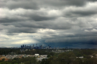
 Typical storm weather approaching Sydney, blowing in from the south-west. |
Blobs of high and low barometric pressure don't just move around as independent entities. Surface winds tend to blow outward from high pressure regions and inward towards low pressure regions, in an effort to equalise the pressures. But various factors also work to maintain and even intensify the pressure differentials, again driven by solar heating of the planet. So the blobs move around, change shape and size, diffuse apart and into one another, and reform and intensify, all depending on the local conditions and how the landscape reacts to the heating of the sun.
One weather phenomenon in particular is of special interest. In tropical regions, warm patches of ocean can form. Above these, the air warms and rises, forming a low pressure zone at sea level. Winds begin blowing into the area from surrounding areas, but sometimes the sea temperature is great enough that evaporation substantially moistens the rising air. This causes it to expand more as it rises, creating a greater upwelling of air, in turn further lowering the sea level pressure.
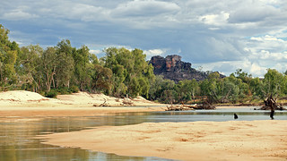
 Damage causes by Tropical Cyclone George in Australia's Northern Territory in 2007. I visited the area a year later and this previously navigable river was still blocked by sand and tree debris. |
The warm moist air that spreads out from the top of the rising air column generates and feeds thick masses of cloud as it climbs in altitude and then disperses. The result is a huge rotating storm, known generically as a cyclonic storm, but called by other names in specific parts of the world. In the South Pacific region they are known as tropical cyclones. In the waters near Asia, they are typhoons. And in the Atlantic Ocean they are called hurricanes.
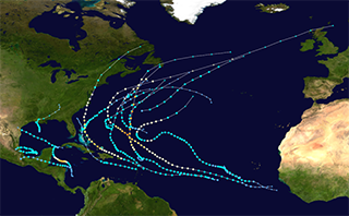
Having formed in the tropical regions, these storms begin life amidst the prevailing pattern of Hadley cell winds blowing from east to west. So the storms usually move westward as they develop and grow stronger. This can track them over large spans of warm ocean, particularly in the northern Atlantic. A storm can start forming just west of Africa, and develop and intensify as it crosses the entire ocean, heading towards the islands of the Caribbean. Now a hurricane, it can bring devastatingly strong winds and intense rainfall to these islands.
 Figure 2: Tracks of all Atlantic hurricanes in 2011. Public Domain image by Wikimedia user Cyclonebiskit from Wikimedia Commons. |
When a hurricane, typhoon, or tropical cyclone hits land, it brings some of the strongest winds found on Earth. The strongest of all are in the smaller and much shorter lived phenomenon of tornadoes, but a hurricane lasts for days and hits hundreds of kilometres of coastline all at once, making the potential for damage enormous. It also brings torrential amounts of rain. The wind whips up huge waves on the ocean, which crash into the coastline.
Increasing the devastation along the shores taking the brunt of the storm's fury is storm surge. This surge is caused by the ferocious wind speeds dragging on the surface of the ocean, causing the water to move roughly in the direction of the wind - it also veers to one side because of the Coriolis effect. This water motion actually changes the local sea level, as the water piles up faster than it can spread out under its own weight. And when this bulge in sea level hits a coastline, the water has nowhere to go and piles up even further, creating what appears to be an unusually high tide. This surge can run up rivers, spill over sea walls, and flood across low-lying land. The combination of heavy rain and storm surge can produce terrible floods.
 Dust storm in Sydney, 23 September, 2009. I took this photo more than an hour after sunrise. |
The probes we have sent to explore Mars must endure occasional storms as well, which whip the Martian surface dust into the thin atmosphere, obscuring vision like an Earthly sandstorm or dust storm. There is almost no easily available water on Mars, so there is no rain, but the evidence of many dry river channels shows that there once was.
But perhaps the most impressive weather systems we know of are those of the giant planets. Jupiter in particular is know for the coloured bands in atmosphere. These are the product of heating and convection cells forming bands of latitude with greater or lower atmospheric pressure, just like on Earth. The colours come from various molecules which are carried up or down by the convection cells. And just as on Earth, local regions of different pressure form swirling storms. The difference is that on Jupiter the storms are much bigger and can last much longer. The Great Red Spot is such a storm and was first verifiably recorded by Samuel Schwabe in 1831. Smaller storms develop and fade away over time scales of decades.
Saturn, Uranus, and Neptune also have pressure bands, but like Earth's they are less immediately visible. And Venus has curved bands of clouds whose shapes are dictated by the same physical processes.
If and when we ever meet alien beings from some other planet, we know that we will at least have something to talk about. "How's the weather?"
|
LEGO® is a registered trademark of the LEGO Group of companies,
which does not sponsor, authorise, or endorse this site. This material is presented in accordance with the LEGO® Fair Play Guidelines. |