
| Archive Blog Cast Forum RSS Books! Poll Results About Search Fan Art Podcast More Stuff Random |
|
Classic comic reruns every day
|
1 {photo of an ancient map}
1 Caption: Here be dragons
|
First (1) | Previous (3300) | Next (3302) || Latest Rerun (2895) |
Latest New (5380) First 5 | Previous 5 | Next 5 | Latest 5 Annotations theme: First | Previous | Next | Latest || First 5 | Previous 5 | Next 5 | Latest 5 This strip's permanent URL: http://www.irregularwebcomic.net/3301.html
Annotations off: turn on
Annotations on: turn off
|
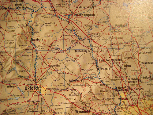
 1:1,000,000 map of region just northwest of London. |
Moving into the senior school years of 11 and 12, the elective choices were much broader. By that time it was clear that my aptitudes and interests lay in pursuing science and technology related subjects, and there wasn't room in my timetable for geography any more. I actually considered sticking with geography and not taking chemistry, but my mother made me a deal. She would get me a subscription to National Geographic to make up for dropping geography.
I have now maintained that subscription continuously for almost thirty years. Every issue I've received, over 300 by now, I have read cover to cover. (Upon attaining my first job, I also subscribed to Australian Geographic for a few years, but I found its writing/editing style oddly distracting, so gave it up.) Unlike the old chestnut about girlie magazines, I read National Geographic both for the articles and the photos. As a keen photographer, National Geographic landscapes have always inspired me. But standing above the articles and the photos is another feature of National Geographic. Maps.
Over the years I have given away all my old copies of the magazine, and now I pass them all on to my mother, because she also likes reading about the world. But she never gets the lift-out map supplements. I still have every single one, right back to the first issue I received as a teenager, filed away safely in the same place as my tax receipts and bank statements. The earliest ones have tape marks on them from when they were stuck up on my bedroom walls. Yes, other kids had posters of rock stars on their walls, I had National Geographic maps. (Actually there were also some rock stars. But I don't have those posters any more.)
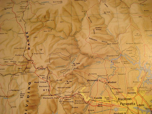
 1:1,000,000 map of region just northwest of Sydney. Compare to above. |
I also had a large, fairly expensive atlas of the world, which I still have on my bookshelf. It is a bit out of date now, with countries such as Yugoslavia in it. But it has lovely detailed maps of swathes of Europe at the same scale as maps of parts of Australia. The difference is startling. In Europe, there are towns and villages dotted everywhere, like ants crawling over a sticky counter, connected by an intricate spider-lacework of roads and country lanes. In Australia the few towns are separated by vast expanses of empty space. In Europe, you can't drive for more than a few kilometres before hitting the next town or village. In Australia, you can drive for several hours without seeing any person or habitation.
Discovering Dungeons & Dragons was also an experience in discovering new types of maps. Part of the game involves not just using maps, but making maps, either as a Dungeon Master preparing an adventure for the players, or as a player roleplaying the procedure of exploring and drawing a map to keep track of your progress. Besides the fun of roleplaying and the fantasy aspects, I think this is one of the contributing reasons for why games like this are popular. Now there are online communities dedicated not merely to roleplaying games, but to making maps for use in roleplaying games. And there are several software tools to make the job easier and the end products more beautiful, such as Campaign Cartographer and Hexographer.
 Playing D&D; a map is central. |
Maps are used in movies and certain comics when indicating characters travelling across the globe. It's a convenient shorthand to encapsulate both the time required and the old fashioned romance of travel. And there is indeed something romantic about finding your way in a foreign place with an unfolded sheet of paper. Venice in particular is especially rewarding if you tackle it with a good quality map, but mostly to find your way back to your hotel after a day spent wandering largely at random, exploring the alleys and canal-side lanes to see what lies around the next corner. A map can help you navigate, but it can't help you explore. I felt duty bound to mention Venice in a discussion of maps. Every book I read about Venice discusses how difficult it is to map adequately because of the intricacy of its labyrinthine calli; and every book I read about maps discusses Venice as the ur-example of a place that needs to be mapped. My map of Venice sits in the same drawer as my National Geographic maps, but with highlighter pen markings on it indicating every calle and sottopassaggio I have walked down in that city.
I have a similar map, closer to home. I printed out a copy of this map of North Sydney Council, the local government area in which I live. It shows every street and walking path in the council area, and since 2011 my wife and I have been engaged in a project to walk the length of every one of those streets and pedestrian paths. The idea is to go to and see every place in our local area in detail, discovering the hidden parks and views that are within walking distance of where we live, but that we would never otherwise have known about. As I write this, we have last weekend finished the second last walk, and we expect that on our next expedition we will complete this project. We will have seen everything on this map: every street, every park, every building, every house. We've discussed what to do after we finish this, and we've decided to try the same thing in the Sydney City council area - the region which encompasses the city centre and the main tourist sights of our city.
In this digital age, maps are available to us all at the click of a button. Google Maps is the pre-eminent of several online mapping services that can transport you anywhere in the world that you would like to see, integrated with not only stylised maps but also photographs of what parts of the planet actually look like, both from above and ground level. Many people navigate their cars now with interactive electronic maps that track their position using GPS. I don't - I still like flipping through the street directory, or unfolding a paper map when on longer trips through the country. But I do have access to electronic maps from my iPad, which I used on my last few trips overseas, to find my position and navigate in foreign cities.
So I don't really need paper maps any more. But I want them. There's just something about them that's a little bit magical.
|
LEGO® is a registered trademark of the LEGO Group of companies,
which does not sponsor, authorise, or endorse this site. This material is presented in accordance with the LEGO® Fair Play Guidelines. |